Last checked 13 Oct 2026 · Prepared by the Office of MushroomWale.com · Sources listed under “In detail”.
इतिहासHistory & significance
The face (mukh) of the bull — worshipped as Neelkanth Mahadev, a natural rock face.
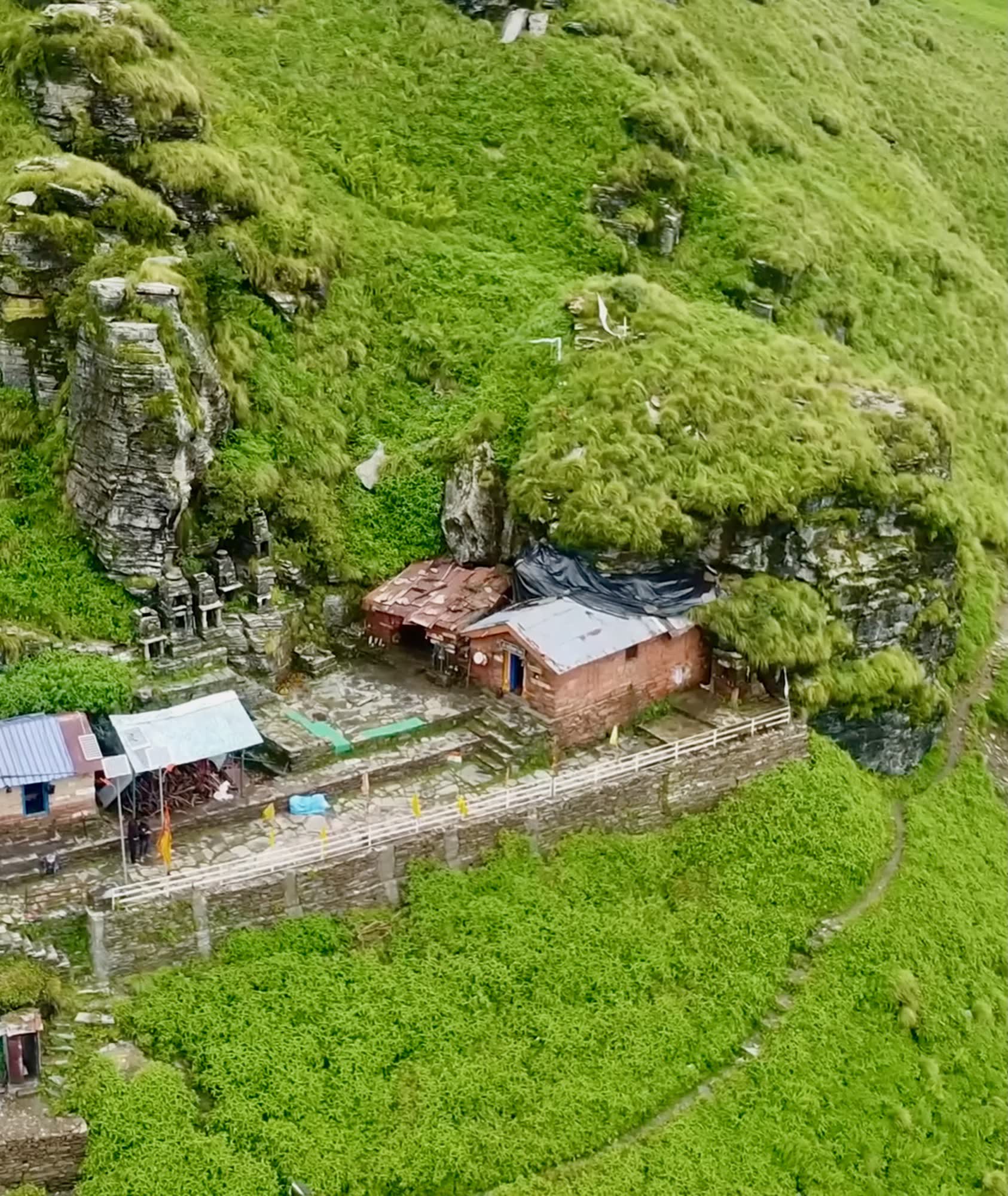
The face of the bull appeared at Rudranath. It is worshipped as Neelkanth Mahadev — a self-manifested (swayambhu) rock face inside a natural cave, which the priests decorate with flowers and silver.
Behind the temple flows the Vaitarani, the river souls are believed to cross after death, so many pilgrims perform pind daan for their ancestors here. Four sacred kunds lie around the shrine: Surya Kund, Chandra Kund, Tara Kund and Manas Kund.
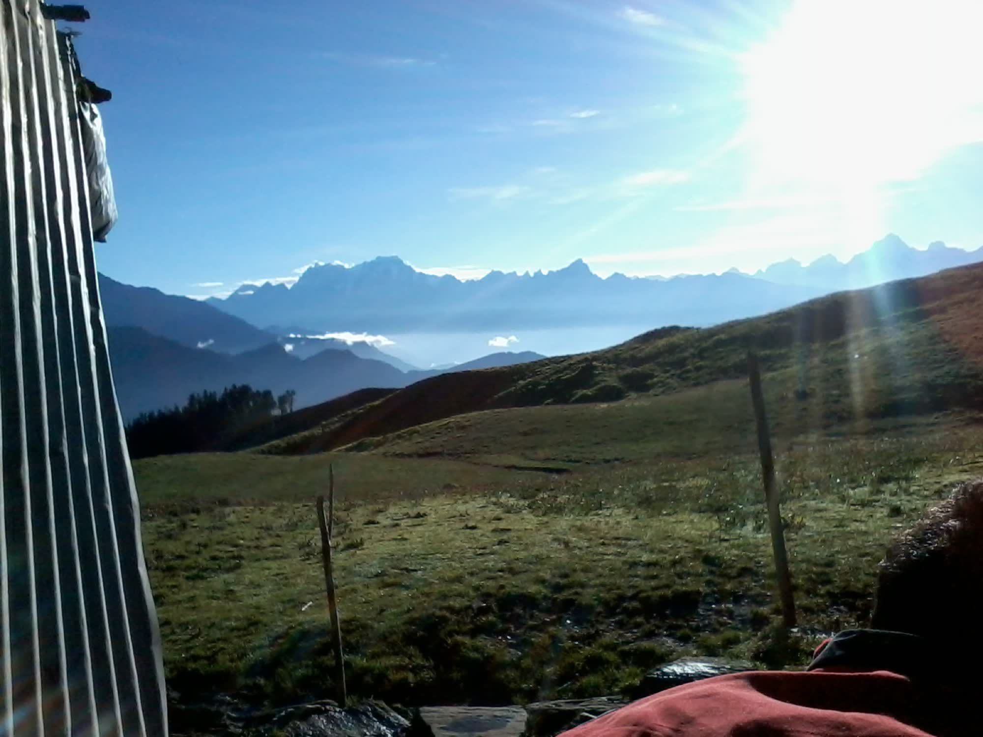
The usual trail from Sagar climbs through oak forest to Lyuti Bugyal and Panar Bugyal, one of the highest meadows in the Himalaya. From there it crosses the Pitradhar ridge, where pilgrims leave stones for their ancestors, before descending to the temple. Nanda Devi, Trishul, Nanda Ghunti and Hathi Parvat fill the horizon.
Important points
Neelkanth Mahadev — the face of Shiva in a natural rock cave
Toughest trek of the five; the longest climb and fewest facilities
Panar Bugyal — high meadows with views from Nanda Devi to Trishul
Vaitarani river and four sacred kunds; pind daan for ancestors
विस्तारIn detail
Rudranath, in full detail
The building and its worship, the festivals, the trail stage by stage, month-by-month weather, facilities on the way, and the customs to know.
Rudranath is not a built temple in the usual sense. The deity is a natural rock face inside a shallow cave, and the shrine around it is small and simple.
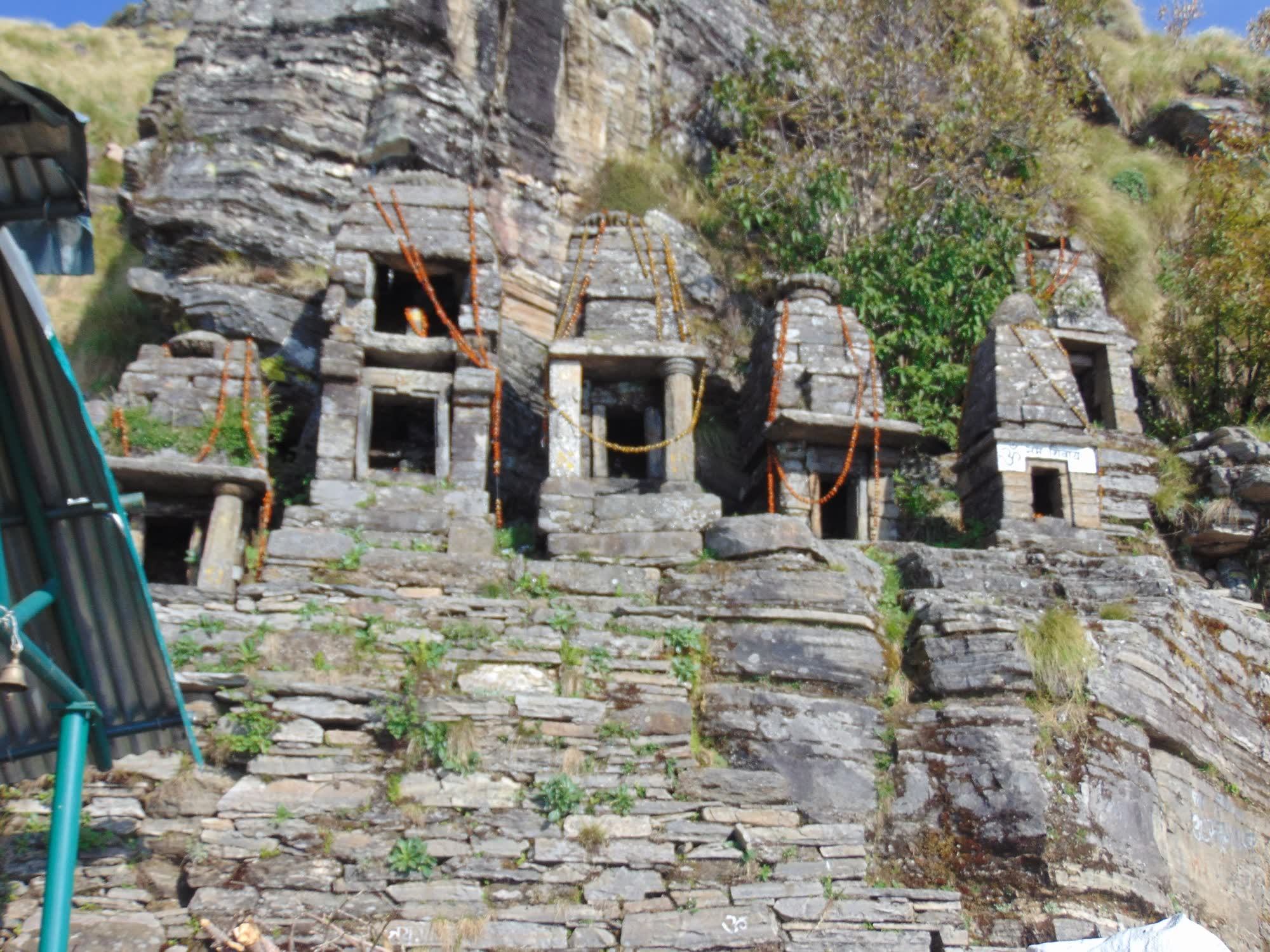
A cluster of small stone shrines stands around the cave on the open hillside. The four kunds lie close by, and the Vaitarani stream flows below.
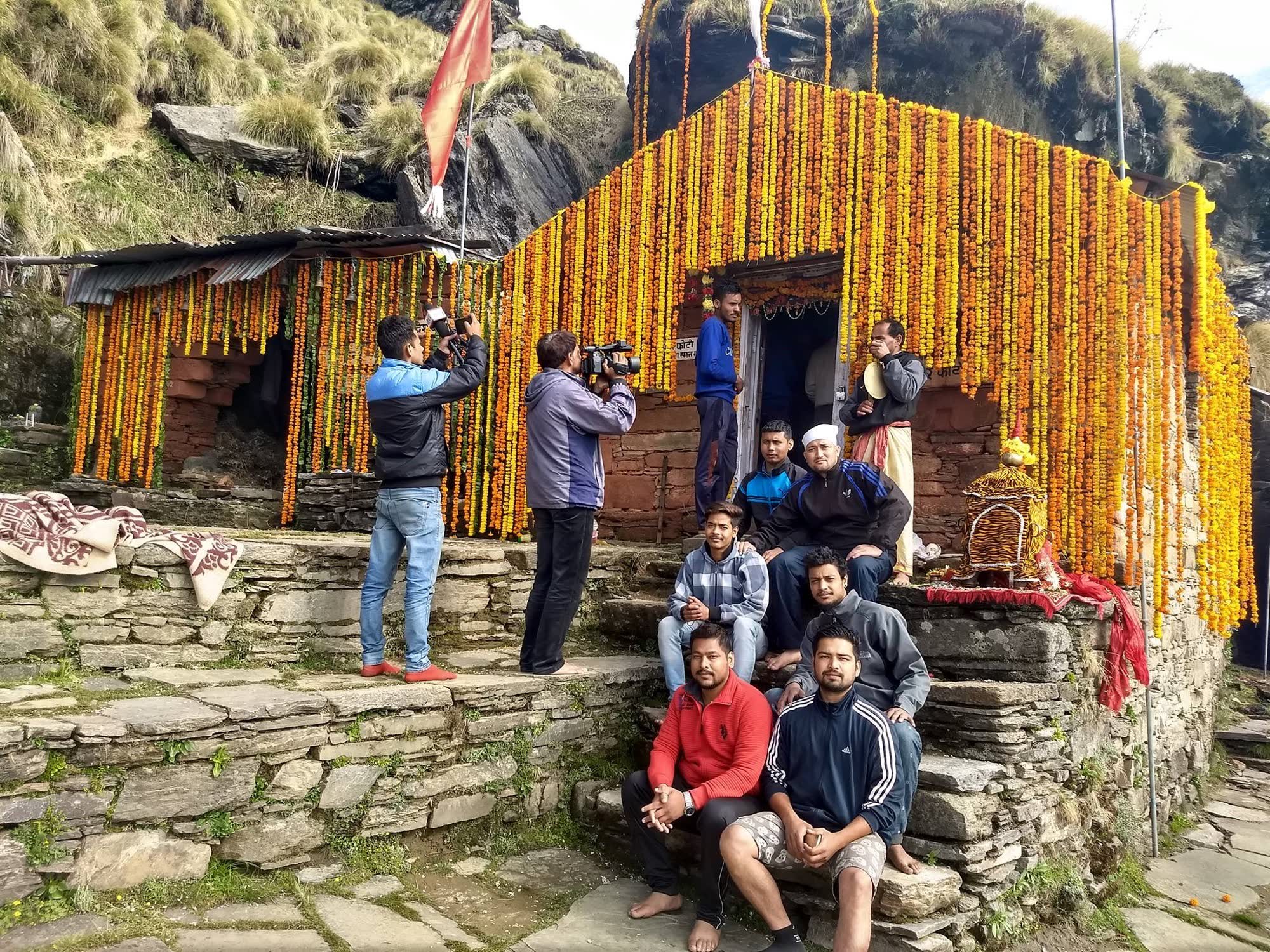
Worship is a morning puja and aarti, darshan through the day, and an evening aarti. The rock face is dressed in flowers and silver for the day.
The priests are Bhatts and Tiwaris of Gopeshwar. When the deity returns in summer, Vandevi, the forest goddess believed to protect the area, is worshipped first.
Many families come to perform pind daan for their ancestors on the Vaitarani. If you plan to do this, arrange it with the priests in Gopeshwar or Sagar before you climb.
May
Doli yatra and kapat opening
The doli leaves Gopinath Temple, Gopeshwar, and is carried up the mountain with a night halt on the way, reportedly at Pung Bugyal. The doors open in the early morning muhurat.
July–August (Raksha Bandhan)
Shravan Purnima fair
An annual fair at the temple on the full moon of Shravan. It is attended mainly by local villagers.
Mid-October
Kapat closing
Usually the earliest of the five to close, often around 17 October. The doli returns to Gopinath Temple, Gopeshwar, for the winter.
1
Sagar → Pung Bugyal
≈ 4.5 km+750 m
A steep climb from the village through fields and oak forest. Shaded but hard from the first step. Tea at Pung in season.
2
Pung Bugyal → Mauli Kharak
≈ 1.5 km+200 m
Continues through oak forest. Steep in places.
3
Mauli Kharak → Lyuti Bugyal
≈ 2 km+200 m
Climbs to the meadow at Lyuti. Huts, tents and a water point.
4
Lyuti Bugyal → Panar Bugyal
≈ 4 km+250 m
Leaves the trees for open meadow. Panar is the usual overnight halt, with huts and tents in season. Fill water here.
5
Panar Bugyal → Pitradhar
≈ 4 km+500 m
The hardest high section. Exposed ridge, no shade and very little water. The trail is easy to lose in fog.
6
Pitradhar → Panch Ganga
≈ 2 km−200 m
The trail now descends gently across meadows. Small streams in season.
7
Panch Ganga → Rudranath
≈ 2 km−100 m
A gentle walk across the slope to the cave temple.
-14°C15°C
Jan≈ −12°C / ≈ −3°CTemple closed. Deep snow.
Feb≈ −11°C / ≈ −2°CTemple closed. Deep snow.
Mar≈ −8°C / ≈ 1°CTemple closed. Snow.
Apr≈ −4°C / ≈ 5°CTemple closed. Snow on Pitradhar.
May≈ 0°C / ≈ 10°COpens mid–late May. Snow patches possible on the ridge.
Jun≈ 4°C / ≈ 13°COpen. Good walking weather until mid-June.
Jul≈ 6°C / ≈ 13°COpen. Monsoon — fog on the ridges, slippery trail.
Aug≈ 6°C / ≈ 13°COpen. Monsoon; meadows full of flowers.
Sep≈ 3°C / ≈ 11°COpen. Best month for clear views once the rain stops.
Oct≈ −2°C / ≈ 8°CCloses mid-October. Approximate.
Nov≈ −6°C / ≈ 4°CTemple closed.
Dec≈ −10°C / ≈ 0°CTemple closed. Snow.
Approximate temperatures at the temple’s altitude (night / day). These are not weather-station records.
Medical aid
None on the trail or at the temple. The nearest hospital is at Gopeshwar. Carry a full first-aid kit and know the signs of altitude sickness.
Mobile network
Little or none above Sagar. Assume you will be out of contact for two to three days.
ATMs & cash
The nearest ATMs are at Gopeshwar. Carry enough cash for huts, food, porters and offerings.
Food on the trail
Seasonal shacks at Pung, Lyuti, Panar and near the temple serve tea and simple meals. They may be closed early or late in the season. Carry snacks.
Ponies / palki / porters
No ponies or palkis; the trail is too steep. Porters and local guides can be hired at Sagar.
Electricity & charging
Little or none on the trail. Some huts have small solar lights. Carry power banks for the whole trip.
Toilets
Practically none. Use the outdoors well away from water sources and carry out tissue.
Drinking water
Water points at Lyuti and Panar, and streams near the temple. Sources are scarce between Panar and Pitradhar, so fill up at Panar. Treat all water.
Do
Hire a local guide or porter at Sagar.
Take two days for the climb, with a night at Panar.
Carry warm clothes, a rain shell and a sleeping bag.
Check the forest-entry rules at Sagar or Gopeshwar before you start; the trail passes through protected forest.
Turn back if fog or snow hides the trail on Pitradhar.
Don’t
Don’t attempt the trek alone.
Don’t start up from Sagar late in the day.
Don’t leave rubbish on the meadows; there is no collection at all.
Don’t disturb the stones and cairns at Pitradhar.
Is there a pony or helicopter to Rudranath?
No. There are no ponies, palkis or helicopter services. You walk, with porters to carry loads if you need them.
Do I need a permit for the Rudranath trek?
The trail passes through protected forest, and a forest-department entry or registration is reportedly required. Rules and timings change, so check at Sagar or with the forest office in Gopeshwar before you start.
Who are the priests at Rudranath?
Bhatts and Tiwaris of Gopeshwar. In winter the worship continues at Gopinath Temple, Gopeshwar.
Can I do pind daan at Rudranath?
Yes. Many families perform it on the Vaitarani behind the temple. Arrange it with the priests in advance.
Based on: Chamoli district administration and press reports on opening and closing (2024–2026) · News on Air (AIR) reports on the Rudranath doli · Uttarakhand Tourism · Trek route records and operator guides · Wikipedia (Rudranath) for cross-checking.
कथाएँThe legends
The stories of Rudranath
Traditional accounts, as told in the Puranas and by the temple communities. Versions differ from valley to valley.
The face of Neelkanth
At Rudranath the face of the bull came up out of the earth. It is worshipped as Neelkanth Mahadev, the blue-throated lord. The face is a natural rock inside a shallow cave. It was not carved, but is believed to have appeared by itself, and the priests dress it in flowers and silver.
The name Neelkanth recalls the churning of the ocean. When the gods and demons churned the cosmic sea, a deadly poison, halahala, rose first. Shiva drank it to save the worlds, Parvati held his throat so the poison would not go further, and it turned his throat blue.
The Vaitarani, river of the departed
Behind the temple flows a stream called the Vaitarani. In Hindu belief, the Vaitarani is the river every soul must cross after death on its way to Yama’s realm.
Here at Rudranath, families perform pind daan, offerings of rice balls for their ancestors. They believe that rites done on its bank help the souls of the departed cross in peace.
Pitradhar, the ridge of the ancestors
The trail crosses its highest point at Pitradhar, the ridge of the ancestors, at about 3,800 metres. Pilgrims stop here and set down small stones in memory of their parents and grandparents. Over generations these have grown into a field of little cairns.
Many walkers say it is the most moving moment of the whole Panch Kedar.
The trishul of Gopeshwar
In winter Rudranath is worshipped in Gopeshwar, at the old Gopinath Temple. A five-metre metal trishul stands in its courtyard, inscribed with letters more than a thousand years old.
Tradition says Shiva hurled it at Kamadeva, the god of desire, who had disturbed his meditation, and it has stood there ever since. People say that if you touch it with only your little finger, it trembles, but not if you push it with all your strength.
Each trail is traced from OpenStreetMap footpaths, and its height is measured every 20 m from satellite terrain data (SRTM). The hiker walks that real profile on a 3D satellite map. Speed comes from Tobler’s hiking function, adjusted for altitude, your pace and rest stops. At every step you see altitude, gradient, oxygen and temperature, and at the end the time you reach the temple.
Ridge-top shrine where pilgrims leave stones for their ancestors.
≈ 4 km before temple
Gopinath Temple, Gopeshwar
Winter seat; a fine 9th–11th-century temple with an ancient trishul.
≈ 5 km from Sagar
Anusuya Devi Temple
Temple of Mata Anusuya; a longer forest route to Rudranath.
Alternate route via Mandal
विश्रामWhere to stay
Stays for Rudranath
Hotels at Gopeshwar; homestays at Sagar; tents and stone huts at Lyuti Bugyal, Panar and Pitradhar; basic dharamshala at the temple.
Rudranath
Gopeshwar · Chamoli
GMVN Tourist Rest House
Hotels
Indicative / night₹1,000 – ₹3,500
District headquarters with full services; base for Rudranath.
Rudranath
Sagar · Lyuti · Panar · Pitradhar
Homestays (Sagar)
Stone huts & tents on the trail
Temple dharamshala at Rudranath
Indicative / night₹400 – ₹1,500
Very basic. Carry a sleeping bag, or rent one at Sagar.
सुझावPilgrim tips
Hire a local guide or porter at Sagar. Above Panar the trail is easy to lose in fog.
Take enough water from Panar. Sources are scarce between Panar and Pitradhar.
Budget two days up. Doing it in one day is for fit trekkers only.
This website is managed by
The Office of MushroomWale.com
A free, independent guide for Panch Kedar pilgrims, prepared and maintained from Uttarakhand. Temple bookings and donations go only through official channels — this site never collects money.